- Home
- Training Courses
- Membership
- About Us
- Instructors Blog
- December 2023: All I Want For Christmas
- November 2023: ESA Report Reviews
- October 2023: Can AI Write an ESA Report?
- September 2023: Getting Paid... or Not
- August 2023: Take Me Back...
- July 2023: To Bid or Not To Bid
- June 2023: Selecting a Supplier
- April 2023: Phase 1 Problems, Part 3
- March 2023: Phase 1 Problems, Part 2
- February 2023: Phase 1 Problems, Part 1
- January 2023: Working Outside in Winter
- 2022 Blogs
- 2021 Blogs
- December 2021: Asbestos in your Home
- Sept 2021: Dirty Jars And Other Bad Things… Part 2
- August 2021: Dirty Jars And Other Bad Things… Part 1
- July 2021: How do you want that drawing to look? Part 2
- June 2021: How Did You Want That Drawing To Look? Part 1
- April 2021: So You Need a RSC... Part 2
- March 2021: So You Need a RSC... Part 1
- February 2021: What's In Your Toolbox? Part 2
- January 2021: What's In Your Toolbox? Part 1
- 2020 Blogs
- December 2020: A Day in the Life, Part 2
- November 2020: A Day in the Life, Part 1
- October 2020: Exploring Your Career Path
- September 2020: So You Want To Start Your Own Business - Part 2
- August 2020- So You Want to Start Your Own Business
- June 2020: Effective Communication
- May 2020: Tips For Working From Home
- April 2020: Conducting ESA’s During a Pandemic
- March 2020: It's Not Easy Being Green
- February 2020: Looking Ahead; Bold Predictions for the Next Decade
- January 2020: Looking Back; A Decade in Review
- 2019 Blogs
- 2018 Blogs
- 2017 Blogs
- 2016 Blogs
- 2015 Blogs
- Find an AESAC Member
Menu- Home
- Training Courses
- » Training Courses
- » Webinar Series
- » Calender of Events
- » Course Registration
- » Course Instructors
- » Testimonials
- Membership
- » Become a Member
- » Certifications
- » Membership Search
- » Update Member Profile
- » Members Only
- » » Member Login
- » » Membership Renewal
- » » Create/Change Password
- » » CESA Certification Application
- About Us
- » About AESAC
- » Course Instructors
- » Contact Us
- Instructors Blog
- » December 2023: All I Want For Christmas
- » November 2023: ESA Report Reviews
- » October 2023: Can AI Write an ESA Report?
- » September 2023: Getting Paid... or Not
- » August 2023: Take Me Back...
- » July 2023: To Bid or Not To Bid
- » June 2023: Selecting a Supplier
- » April 2023: Phase 1 Problems, Part 3
- » March 2023: Phase 1 Problems, Part 2
- » February 2023: Phase 1 Problems, Part 1
- » January 2023: Working Outside in Winter
- » 2022 Blogs
- » » December 2022: Advice To My Younger Self
- » » October 2022: Pre-Purchase Due Diligence
- » » Sept 2022: Words Matter
- » » July 2022: Let Us Come To You
- » » April 2022: Due Diligence
- » » March 2022: Time Management
- » » February 2022: Spinning Augers... Part 2
- » » January 2022: Spinning Augers... Part 1
- » 2021 Blogs
- » » December 2021: Asbestos in your Home
- » » Sept 2021: Dirty Jars And Other Bad Things… Part 2
- » » August 2021: Dirty Jars And Other Bad Things… Part 1
- » » July 2021: How do you want that drawing to look? Part 2
- » » June 2021: How Did You Want That Drawing To Look? Part 1
- » » April 2021: So You Need a RSC... Part 2
- » » March 2021: So You Need a RSC... Part 1
- » » February 2021: What's In Your Toolbox? Part 2
- » » January 2021: What's In Your Toolbox? Part 1
- » 2020 Blogs
- » » December 2020: A Day in the Life, Part 2
- » » November 2020: A Day in the Life, Part 1
- » » October 2020: Exploring Your Career Path
- » » September 2020: So You Want To Start Your Own Business - Part 2
- » » August 2020- So You Want to Start Your Own Business
- » » June 2020: Effective Communication
- » » May 2020: Tips For Working From Home
- » » April 2020: Conducting ESA’s During a Pandemic
- » » March 2020: It's Not Easy Being Green
- » » February 2020: Looking Ahead; Bold Predictions for the Next Decade
- » » January 2020: Looking Back; A Decade in Review
- » 2019 Blogs
- » » November 2019
- » » September 2019
- » » August 2019
- » » July 2019
- » » May 2019
- » » March 2019
- » » February 2019
- » » January 2019
- » 2018 Blogs
- » » November 2018
- » » October 2018
- » » September 2018
- » » August 2018
- » » July 2018
- » » June 2018
- » » May 2018
- » » March 2018
- » » February 2018
- » » January 2018
- » 2017 Blogs
- » » April 2017
- » » June 2017
- » » August 2017
- » » September 2017
- » » December 2017
- » 2016 Blogs
- » » October 2016
- » » September 2016
- » » August 2016
- » » July 2016
- » » June 2016
- » » March 2016
- » » January 2016
- » » December 2016
- » » November 2016
- » 2015 Blogs
- » » April 2015
- » » July 2015
- » » September 2015
- » » October 2015
- » » December 2015
- Find an AESAC Member
By: Bill Leedham, P.Geo, CESA
Last month I discussed the issue of fill materials, specifically what constitutes fill and why the presence of fill materials at a property can be a potential concern for Environmental Site Assessments. This month I will review some of the potential indicators of fill that you should look for during Phase 1 and 2 ESA work.
How do you identify Fill materials during Phase 1 ESA research?
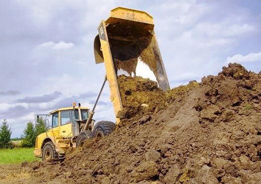
There are several research parameters to check during the Phase 1 ESA research and prior to Phase 2 ESA field work. Evaluate aerial imagery for evidence of fill piles, filled in ponds, ravines, low areas; review a series of topo maps for possible grading and grade changes; review any prior borehole logs and geotechnical reports for evidence/records/notes of fill or suspected fill. Construction inspection reports can also help, as records of deep foundations or foundation alternatives like piles, helical piers, grade beams etc. can all be indications of looser, or unconsolidated or weaker soils (for bearing capacity), any of which could possibly be due to presence of fill. Phase 1 and 2 ESA and other environmental reports (UST removals, demolition, and remedial reports) can also provide information on possible fill placement. Fill and/or manufactured imported aggregate are likely to be present on a developed property for grading, pavement structure, foundation backfill, and engineered fill. Check historical site records, reports, and interviews with owners, tenants, and neighbours for any recorded or anecdotal evidence of fill placement.How do you identify Fill materials in the field?
When you are on site look for evidence of unusual grading or built up areas, filled in areas (gullies, ravines, ponds, or former wetlands), grade changes, and other constructed features such as retaining walls. Ask locals, property owners, and drillers/contractors about their knowledge of area development and conditions. A pre-drilling geophysical survey can also identify fill, possible fill, and changes in soil type. During a subsurface investigation like drilling or test pit excavation look for and note soft soils, low Standard Penetration Test (SPT) or ‘N’-values or abrupt changes in ‘N’-values during split-spoon sampling. Don’t hesitate to ask the driller for their opinion (some drillers are better or more experienced than others in how it ‘feels’ while drilling, and can tell if it feels like drilling through fill). Look for any evidence of buried non-native materials – if you encounter buried topsoil, significant rootlets at depth (not always, some rooting does go deep into subsoil), debris, pavement, coal fragments, clinkers, construction materials (glass, wood, bricks, metals); then everything found above level that is most likely fill. Consider how native soils are originally deposited (via glacial deposition, as sediment from water, wind-borne, etc.), and think how that deposition would look in situ. In many soils, not all (e.g. some tills and conglomerate-type soils) there will be distinct layering, sometimes very uniform in consistency with noticeable changes from one homogenous stratum to another. Then consider how fill may get placed at a site – bulk dumping from a truck, graded by a dozer, mechanically transported and placed. In comparison fill may look ‘dirtier’ with several types of soil in a mix or blend (e.g. a heterogeneous mix of visibly different silt, sand, gravel, organics), sometimes oddly mixed with inclusions. Unless it has been compacted it will likely be looser and appear unconsolidated, and could even get softer and looser with depth (native soils often gain strength with depth). Some of the hardest material to distinguish in the field is fill that is comprised of re-worked native soil, such as a large cut and fill grading for a site. If necessary have a more experienced person review with you and directly examine the soil/fill in the field or at least review retained samples with you. The more soil you drill, sample, see, feel and touch; the better you will get at the task.By:
Bill Leedham, P. Geo., CESA, QP
Bill is the Head Instructor and Course Developer for the Associated Environmental Site Assessors of Canada (www.aesac.ca); and the founder and President of Down 2 Earth Environmental Services Inc. You can contact Bill at info@down2earthenvironmental.ca

In-House Training
Membership
About Us
Contact UsCopyright (c) 2026 Associated Environmental Site Assessors of Canada; AESAC Inc.