- Home
- Training Courses
- Membership
- About Us
- Instructors Blog
- December 2023: All I Want For Christmas
- November 2023: ESA Report Reviews
- October 2023: Can AI Write an ESA Report?
- September 2023: Getting Paid... or Not
- August 2023: Take Me Back...
- July 2023: To Bid or Not To Bid
- June 2023: Selecting a Supplier
- April 2023: Phase 1 Problems, Part 3
- March 2023: Phase 1 Problems, Part 2
- February 2023: Phase 1 Problems, Part 1
- January 2023: Working Outside in Winter
- 2022 Blogs
- 2021 Blogs
- December 2021: Asbestos in your Home
- Sept 2021: Dirty Jars And Other Bad Things… Part 2
- August 2021: Dirty Jars And Other Bad Things… Part 1
- July 2021: How do you want that drawing to look? Part 2
- June 2021: How Did You Want That Drawing To Look? Part 1
- April 2021: So You Need a RSC... Part 2
- March 2021: So You Need a RSC... Part 1
- February 2021: What's In Your Toolbox? Part 2
- January 2021: What's In Your Toolbox? Part 1
- 2020 Blogs
- December 2020: A Day in the Life, Part 2
- November 2020: A Day in the Life, Part 1
- October 2020: Exploring Your Career Path
- September 2020: So You Want To Start Your Own Business - Part 2
- August 2020- So You Want to Start Your Own Business
- June 2020: Effective Communication
- May 2020: Tips For Working From Home
- April 2020: Conducting ESA’s During a Pandemic
- March 2020: It's Not Easy Being Green
- February 2020: Looking Ahead; Bold Predictions for the Next Decade
- January 2020: Looking Back; A Decade in Review
- 2019 Blogs
- 2018 Blogs
- 2017 Blogs
- 2016 Blogs
- 2015 Blogs
- Find an AESAC Member
Menu- Home
- Training Courses
- » Training Courses
- » Webinar Series
- » Calender of Events
- » Course Registration
- » Course Instructors
- » Testimonials
- Membership
- » Become a Member
- » Certifications
- » Membership Search
- » Update Member Profile
- » Members Only
- » » Member Login
- » » Membership Renewal
- » » Create/Change Password
- » » CESA Certification Application
- About Us
- » About AESAC
- » Course Instructors
- » Contact Us
- Instructors Blog
- » December 2023: All I Want For Christmas
- » November 2023: ESA Report Reviews
- » October 2023: Can AI Write an ESA Report?
- » September 2023: Getting Paid... or Not
- » August 2023: Take Me Back...
- » July 2023: To Bid or Not To Bid
- » June 2023: Selecting a Supplier
- » April 2023: Phase 1 Problems, Part 3
- » March 2023: Phase 1 Problems, Part 2
- » February 2023: Phase 1 Problems, Part 1
- » January 2023: Working Outside in Winter
- » 2022 Blogs
- » » December 2022: Advice To My Younger Self
- » » October 2022: Pre-Purchase Due Diligence
- » » Sept 2022: Words Matter
- » » July 2022: Let Us Come To You
- » » April 2022: Due Diligence
- » » March 2022: Time Management
- » » February 2022: Spinning Augers... Part 2
- » » January 2022: Spinning Augers... Part 1
- » 2021 Blogs
- » » December 2021: Asbestos in your Home
- » » Sept 2021: Dirty Jars And Other Bad Things… Part 2
- » » August 2021: Dirty Jars And Other Bad Things… Part 1
- » » July 2021: How do you want that drawing to look? Part 2
- » » June 2021: How Did You Want That Drawing To Look? Part 1
- » » April 2021: So You Need a RSC... Part 2
- » » March 2021: So You Need a RSC... Part 1
- » » February 2021: What's In Your Toolbox? Part 2
- » » January 2021: What's In Your Toolbox? Part 1
- » 2020 Blogs
- » » December 2020: A Day in the Life, Part 2
- » » November 2020: A Day in the Life, Part 1
- » » October 2020: Exploring Your Career Path
- » » September 2020: So You Want To Start Your Own Business - Part 2
- » » August 2020- So You Want to Start Your Own Business
- » » June 2020: Effective Communication
- » » May 2020: Tips For Working From Home
- » » April 2020: Conducting ESA’s During a Pandemic
- » » March 2020: It's Not Easy Being Green
- » » February 2020: Looking Ahead; Bold Predictions for the Next Decade
- » » January 2020: Looking Back; A Decade in Review
- » 2019 Blogs
- » » November 2019
- » » September 2019
- » » August 2019
- » » July 2019
- » » May 2019
- » » March 2019
- » » February 2019
- » » January 2019
- » 2018 Blogs
- » » November 2018
- » » October 2018
- » » September 2018
- » » August 2018
- » » July 2018
- » » June 2018
- » » May 2018
- » » March 2018
- » » February 2018
- » » January 2018
- » 2017 Blogs
- » » April 2017
- » » June 2017
- » » August 2017
- » » September 2017
- » » December 2017
- » 2016 Blogs
- » » October 2016
- » » September 2016
- » » August 2016
- » » July 2016
- » » June 2016
- » » March 2016
- » » January 2016
- » » December 2016
- » » November 2016
- » 2015 Blogs
- » » April 2015
- » » July 2015
- » » September 2015
- » » October 2015
- » » December 2015
- Find an AESAC Member
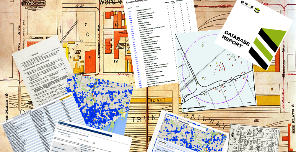
One of the most important tasks for any consultant working on a Phase 1 Environmental Site Assessment (ESA) is the research component. The primary purpose of the ESA is to determine actual or potential sources of environmental concern that may be associated with the subject Site, as well as surrounding and nearby properties; which typically involves looking at a lot of environmental databases. Sufficient relevant data must be reviewed to confirm the site and area history, to assess current and historical activities, and to use this data to evaluate potential environmental issues.
Getting the ‘Right’ Data
Before one can accurately assess the data, you must determine what specific data is required, and balance those requirements with the availability (and costs) of such data. This may vary with the type of ESA being conducted, the objectives of the ESA stakeholders, the geographic location and the applicable regulations governing the assessment. For example the Canadian Standards Association under CSA-Z-768-01 specifies mandatory and optional research items for Phase 1 ESA, which are sufficient for transactional due diligence. However when a Record of Site Condition (RSC) is required for a change in land use (in Ontario only) additional mandatory research items are required by the Ontario Ministry of the Environment and Climate Change under Ontario Regulation 153/04, as amended. A different set of data is required to complete the ESA process for an Upstream Oil and Gas site in Alberta, including site-specific records regarding drilling muds and oil well production. The consultant must therefore pre-determine the use and objectives of the ESA, and follow all the applicable regulatory requirements to properly complete the assessment. The Site locale can also influence the type and amount of information that is available. You can expect to spend extra time researching more databases for an urban setting than rural, and if you are looking at an old industrial property in a major city some records can go back over 150 years. Unique settings like First Nations land may yield less published data, with more information to be found in the community’s oral history; so the assessor will need to include appropriate consultation, communication, and interviews to gather their required data.
“Not everything that can be counted counts; and not everything that counts can be counted.” Albert Einstein
Getting the Data ‘Right’
One of the best tools I have found for this research, and one I highly recommend in AESAC’s Phase 1 ESA training course, is an environmental database report from Environmental Risk Information Services (ERIS). ERIS has been providing customized database reports to consultants, developers, insurers, municipalities and others since 1999 in Canada, and since 2013 in the United States. When determining ESA research requirements, or ordering an ERIS database you should always consider the following:
- Understand the ESA and client objectives, and follow the appropriate regulatory standards.
- Determine how far back your historical review must extend (i.e. when was Site’s first developed use that could impact the Site).
- Gather as much information as you can about current and prior site owners and occupants, and ensure you have a complete description of your Site (legal description, street address, geographic coordinates, and plan showing full extent of subject property).
- Determine the required search distances for your study area (both by regulation and to adequately assess environmental issues affecting your site).
- Relay all the appropriate and relevant information to your database administrator, or research provider, and follow up if there are any uncertainties.
- Conduct additional research as needed with the municipality, ministry or other government agencies in order to validate records of interest or concern.
ERIS (www.eris.ca) has over 6 million records in 488 databases from Provincial, Federal and Private sources. 12,000 to 16,000 Site reports and 30,000 to 40,000 historical products are ordered every year in Canada.
In my next article I will discuss the use of the ERIS database report, and review some of the common problems and solutions encountered with environmental databases in general.By:
Bill Leedham, P. Geo., CESA, QPESABill is the Head Instructor and Course Developer for the Associated Environmental Site Assessors of Canada (www.aesac.ca); and the founder and President of Down 2 Earth Environmental Services Inc. (www.down2earthenvironmental.ca)

In-House Training
Membership
About Us
Contact UsCopyright (c) 2026 Associated Environmental Site Assessors of Canada; AESAC Inc.